


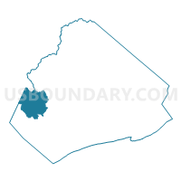
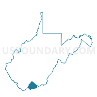
Voting District 60, Mercer County, West Virginia
About
Outline

Summary
| Unique Area Identifier | 691379 |
| Name | Voting District 60 |
| County | Mercer County |
| State | West Virginia |
| Area (square miles) | 17.61 |
| Land Area (square miles) | 17.52 |
| Water Area (square miles) | 0.09 |
| % of Land Area | 99.51 |
| % of Water Area | 0.49 |
| Latitude of the Internal Point | 37.38640900 |
| Longtitude of the Internal Point | -81.28621050 |
Maps

Graphs
Select a template below for downloading or customizing gragh for Voting District 60, Mercer County, West Virginia


Neighbors
Neighoring Voting District (by Name) Neighboring Voting District on the Map
- Voting District 1, McDowell County, WV
- Voting District 10, Wyoming County, WV
- Voting District 17, McDowell County, WV
- Voting District 42, Mercer County, WV
- Voting District 46, Mercer County, WV
- Voting District 61, Mercer County, WV
- Voting District 68, Mercer County, WV
- Voting District 69, Mercer County, WV
Top 10 Neighboring County Subdivision (by Population) Neighboring County Subdivision on the Map
- District III, Mercer County, WV (21,345)
- District I, Mercer County, WV (18,572)
- District 1, Wyoming County, WV (7,419)
- North Elkin district, McDowell County, WV (4,817)
Top 10 Neighboring Place (by Population) Neighboring Place on the Map
Top 10 Neighboring Unified School District (by Population) Neighboring Unified School District on the Map
- Mercer County School District, WV (62,264)
- Wyoming County School District, WV (23,796)
- McDowell County School District, WV (22,113)
Top 10 Neighboring State Legislative District Lower Chamber (by Population) Neighboring State Legislative District Lower Chamber on the Map
- State House District 22, WV (33,043)
- State House District 24, WV (17,083)
- State House District 23, WV (14,616)
Top 10 Neighboring State Legislative District Upper Chamber (by Population) Neighboring State Legislative District Upper Chamber on the Map
Top 10 Neighboring 111th Congressional District (by Population) Neighboring 111th Congressional District on the Map
Top 10 Neighboring Census Tract (by Population) Neighboring Census Tract on the Map
- Census Tract 32, Wyoming County, WV (4,911)
- Census Tract 9, Mercer County, WV (3,518)
- Census Tract 16, Mercer County, WV (1,745)
- Census Tract 9536, McDowell County, WV (1,487)